
An extratropical cyclone of Mediterranean origin, which crossed the Balkan Peninsula, positioned itself over the western basin of the Black Sea during the last 36 hours. The atmospheric fronts associated with this cyclone generated heavy rainfall across the extracarpathian regions of Romania. This meteorological development led to significant water accumulation, particularly in Dobrogea, southern Moldova, and western Muntenia.
The severe weather episode was monitored using the high-precision instruments of the RADO-Bucharest station, part of the ACTRIS (Aerosol, Clouds and Trace gases Research Infrastructure) European research network. The RADO-Bucharest station is operated by the National Institute for Research and Development in Optoelectronics – INOE 2000. Strategically located near the capital city, RADO-Bucharest’s main objective is to collect and provide data on essential climate variables and atmospheric composition to European networks. These data are used in models for air quality forecasting and climate change assessment.
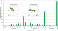
Between October 7, 15:00 local time (12:00 UTC), and October 9, 09:00 local time (06:00 UTC), the meteorological station at RADO-Bucharest recorded a total of 77.33 L/m² of precipitation over a 54-hour period (Figure 1). This amount exceeds the climatological mean precipitation for October by approximately 50%. Lower rainfall totals during the first part of the period (29.61 L/m²) were influenced by the westward movement of the cold front associated with the Mediterranean depression. Subsequently, the redirection of the atmospheric circulation to a predominantly easterly component led to a significant increase in precipitation (44.68 L/m²), as a result of the cyclone’s re-intensification over the Black Sea.

Figure 1. Precipitation and wind roses corresponding to October 7 and 8, 2025, recorded by the meteorological station located at RADO-Bucharest.
Cloud cover and precipitation monitoring were also carried out using the cloud radar (RPG_FMCW-94-DP), integrated into the Cloudnet network, a European infrastructure dedicated to the detailed analysis of clouds and their interactions with the atmosphere (Figure 2). These radars enable real-time observation of cloud structure and dynamics, as well as the processes involved in precipitation formation, providing crucial data for understanding the hydrological cycle and its effects on the climate. Through the Cloudnet network, the collected data are standardized and made available to the scientific community, thereby supporting improvements in weather forecasting and climate modeling. Throughout the monitoring period, the clouds passing over the RADO-Bucharest station reached altitudes of up to 10 km. Radar reflectivity values of up to 12 dBZ indicated the presence of small precipitation particles, corresponding to a low precipitation rate—consistent with the cumulative three-hour intervals shown in Figure 1.
")
Figure 2. Radar reflectivity factor recorded by the RPG_FMCW-94-DP cloud radar at the RADO-Bucharest station during the interval October 7, 2025 (00 UTC) – October 8, 2025 (12 UTC).
As a general conclusion, the precipitation episode of October 7–8, 2025, although resulting in rainfall totals that considerably exceeded the climatological averages for October, was beneficial given the soil moisture deficit recorded during the summer months, thereby helping to alleviate the effects of agricultural drought. A secondary benefit of this precipitation event was the improved air quality measured at the RADO-Bucharest station. Data from the GRIMM EDM 180 optical particle counter show low mass concentrations of PM1, PM2.5, and PM10 throughout the entire monitoring period.